Top 10 Hiking Trails in Iceland

Iceland is known for its breathtaking views, unspoiled nature, and beautiful terrain. There are no mosquitoes or bears or any dangerous animals to be found. You will find hiking and trekking opportunities at every corner and really, the biggest challenge is selecting a trail. To help you decide which trails to choose, we have made this little list.
Here go the TOP 10 HIKING TRAILS IN ICELAND!
10. Mount Esja
Duration: 2 to 3 hours up and 1 to 2 hours down
Activity Level Scale: Easy (2/5)
Experience: Little to none, but make sure to check the forecast!
Path Conditions: Excellent, well marked and multiple options
Water Supply: A stream runs down the mountain where you can fill up with fresh water
Challenges: The trail can get pretty steep
Good to know: There is a café down at the foothills. At the right side of the parking lot. It is a wonderful stop to make before or after the hike. There you will find some local friendly staff and delicious treats.
Esja or Esjan (the Esja) is undoubtedly a significant token in Reykjavik’s skyline. It is a grandiose mountain range within the city border and many locals see this mountain as their natural exercise spot. The trail is so popular that you can even catch a public bus () to the foothills of the mountain. It is best to hike Esja in good weather as visibility is important in its steeper areas.
There are a few different paths one can take. They are all marked with a scale from 1-3 so you can control the challenge a bit yourself. Surely the perfect couple of hours city break from Reykjavík.
9. Kjolur
Duration: 2 to 3 days. 4 to 7 hours per day
Activity Level Scale: Challenging (4/5)
Experience: Highly experienced or with a good guide
Path Conditions: Well marked but less travelled
Water Supply: Some streams where you can find fresh and clean water and at the mountain huts
Challenges: Remoteness and weather conditions
Good to know: Our version of the Kjolur trail is not as extreme as the 2-3 day one but offers a day out on the trail capturing the highlights and hot spring bathing! It is an excellent choice for those who wish to explore the trail without having to be intensely experienced or equipped.
Pro Tip: Bring a bathing suit!
The trail along Kjolur is often nicknamed ‘the Haunted Highway’. The name refers to the challenges Icelanders faced when trying to cross the gruesome highlands on horses following this rough and often brittle road. The path takes you between glaciers and volcanoes and runs through the center of Iceland. Kjolur connects the North to the South and back in the day this was the quickest way to travel between. The travel is known to be challenging, especially due to the unforgiving weather conditions but if you are well prepared and experienced this notorious trail is a trip of a lifetime.
8. Glymur ‘The Trail to the Waterfall’
Duration: 3 to 4 hours hiking
Activity Level Scale: Easy/Moderate (2-3/5)
Experience: Little experience needed
Path Conditions: Well marked and easy to follow
Water Supply: You will cross the river from the waterfall a few times giving you plenty chances to fill up or take a sip
Challenges: The trail is pretty steep and the water crossing requires balance
Good to know: There are no facilities linked with the waterfall’s hike so make sure to go to the bathroom and get something to eat before the hike.
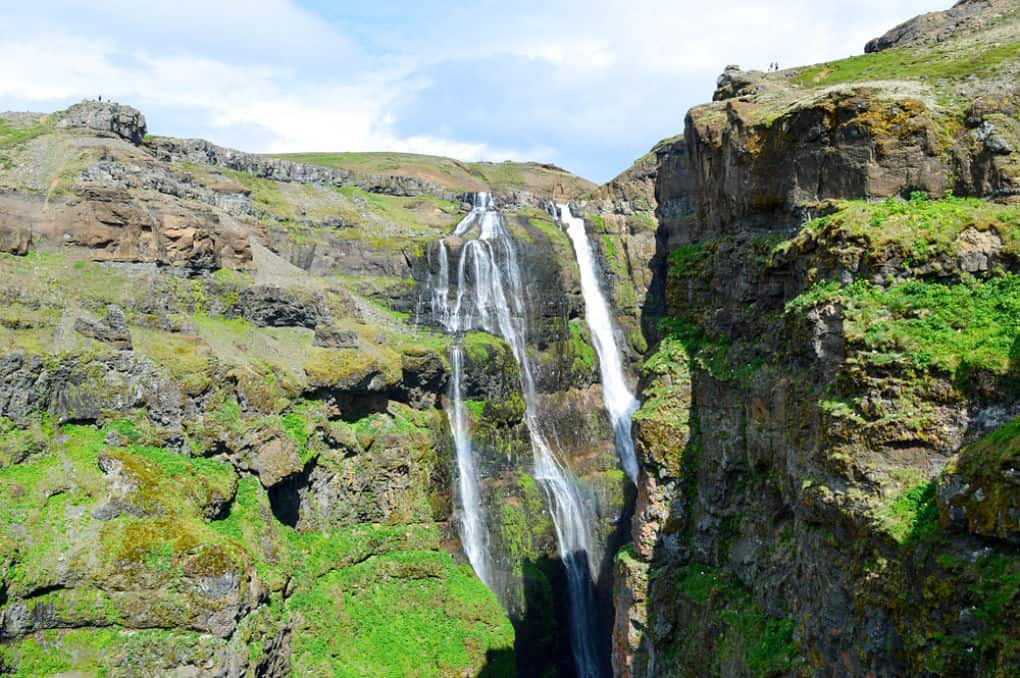
The hike to Glymur is an incredibly scenic one. Waterfalls, clear streams, and beautiful birch await you along with a lava cave and other unique features. Glymur waterfall is located only about an hour away from the city center, tucked in the valley of Hvalfjordur. The hike can get pretty steep at the end so make sure you are prepared shoe wise. However, steepness tends to bring splendor views and this trail is not the exception. Prepare to bust out your camera and make sure to remember to turn around regularly.
Our favorite way to do the trail is up on the right side of the river, crossing it on top and going down at the other side. This will give you an opportunity to explore the dazzling water wonder from different angles. Just remember to bring water shoes or prepare for some cold feet.
7. Thakgil
Duration: Mostly 1 to 2 hours depending on your pace
Activity Level Scale: Very easy (1/5)
Experience: Little to none
Path Conditions: Flat and soft, although not well marked
Water Supply: You can fill up your water bottle at the campsite or in rivers or streams along the way
Challenges: Getting there in winter can be a challenge. Otherwise, no obvious challenges
Good to know: The campsite is open every year from the 1st of June until the 31st of August.
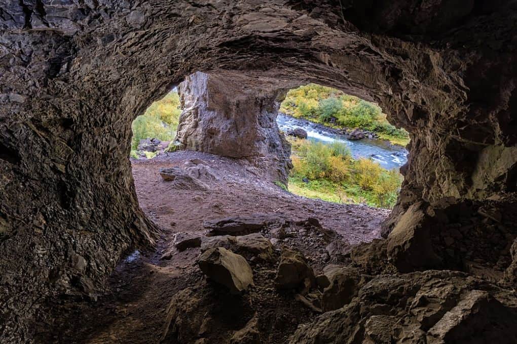
Thakgil is one of these hidden hiker gems you find in Iceland. It is located only about 30 minutes driving from Vik off the Ring Road and the path there is absolutely gorgeous. The road is gravel but during summer time it is suitable for most cars.
Thakgil is located in between glaciers and volcanic sand plains but is a fertile oasis on its own. Once you arrive you are spoiled with choice, trails, and attractions, making Thakgil the perfect hiking destination. It is especially great for those looking to stay in one place but to hike out during the day. Thakgil has an amazing campsite, perfect for families and nature enthusiasts. Most of the hikes in the area begin at the campsite. Some of the hiking trails you must visit are the ones to Remundargil canyon and the one into the creek with the waterfall. If you follow the hydro plant feeding the campsite you will find the creek.
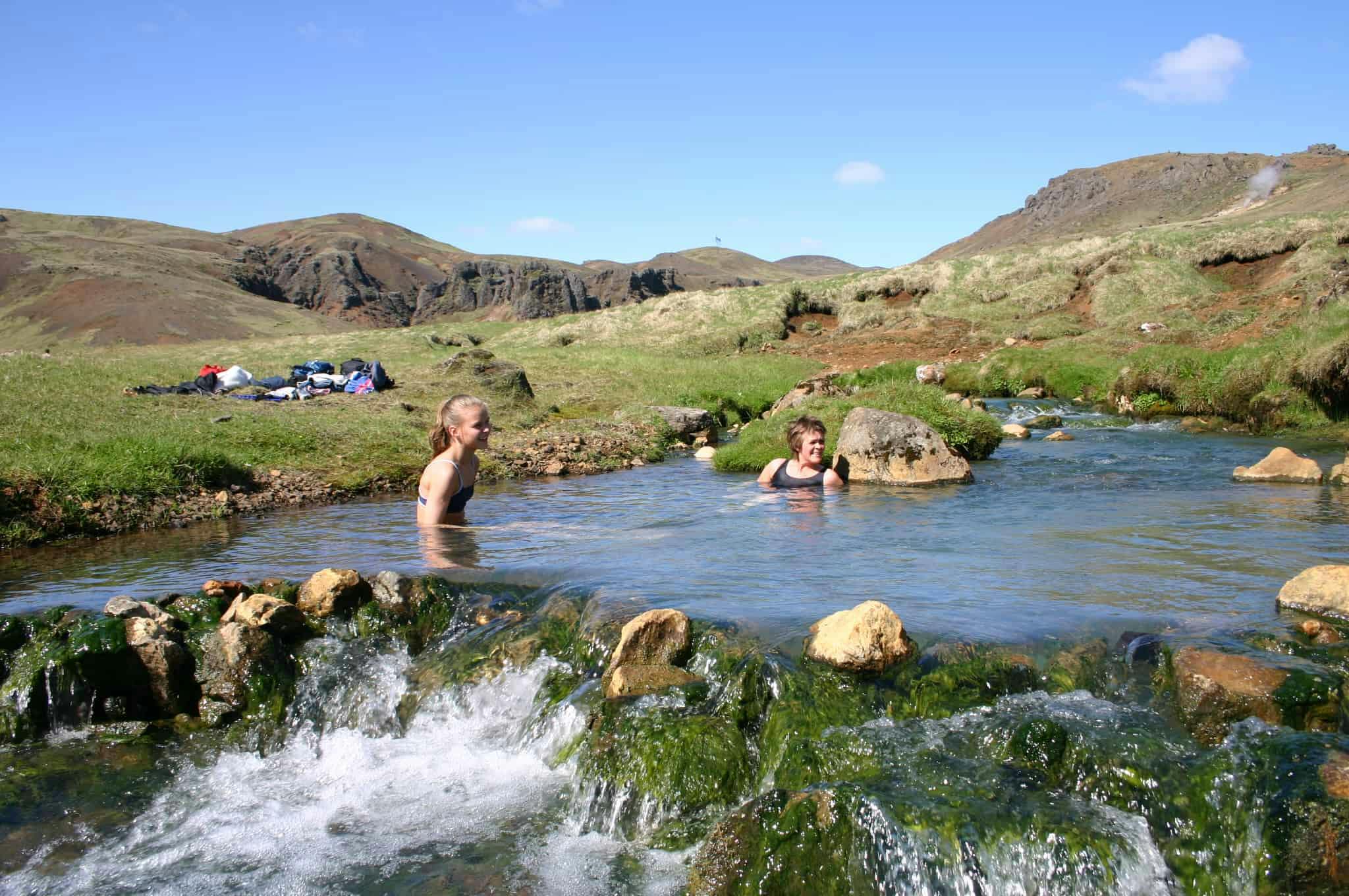
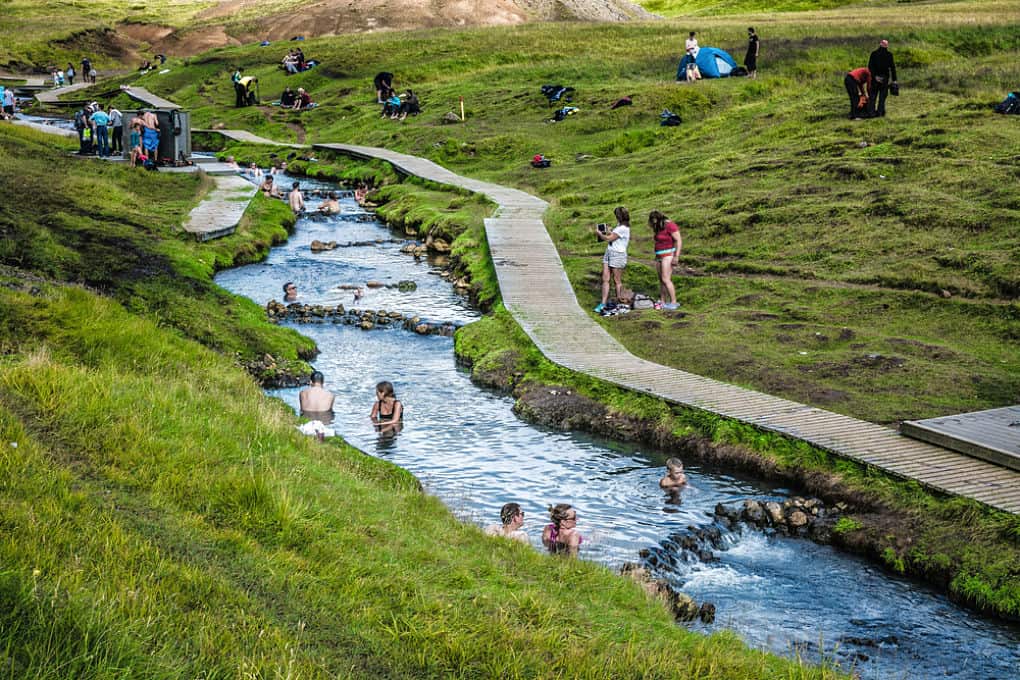
6. Reykjadalur ‘The Smokey Valley’
Duration: 3 hour hiking back and forth
Activity Level Scale: Easy (2/5)
Experience: Little to none
Path Conditions: Well marked and easily recognizable, signs with information along the way
Water Supply: Bring your own water
Challenges: It is important to stay on the trail as boiling hot springs surround the trail
Good to know: there are no proper changing facilities so you might want to wear your bathing suit underneath whilst hiking up

Reykjadalur valley is one of the most popular hikes to do in Iceland. It can easily be done as a part-day activity and with the bathing takes about 3-3,5 hours. Drive to Hveragerdi and follow the road to the mountain on the left. Park your car at the parking lot below the valley and head on up the tracks. The trail is well marked and in excellent shape. Upon arrival, you will be met with the sulfur smell which will grow increasingly throughout the hike. Multicolored bubbling hot springs, smokey pillars and geothermal activity dominate the area which gives it the name ‘the Smokey Valley’.
Make sure to turn around every now and then while hiking up the hills. You will be met with breathtaking views over the South Coast and on a good day even to the Westman Islands!
The river running through the valley gets warmer the higher you go. This has led to some areas of the river being more popular than others. Special bridges have been built on each side of the location with the most comfortable temperature and we recommend to bath there. This is the true Viking bath, ‘all natural’!
If you want to join a tour to get all the local knowledge, a geological lesson and a great group of like-minded travelers the Hot Springs and Lava Cave Hike might be just the thing for you!
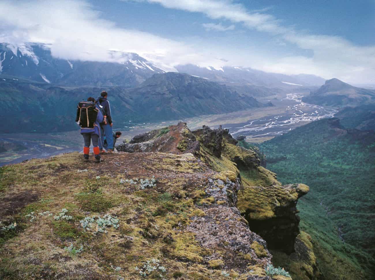
5. Fimmvorduhals ‘Thorsmork Volcano Hike’
Duration: 10-12 hours
Activity Level Scale: Moderate Plus (3,5/5)
Experience: Guide required
Path Conditions: Some parts can be covered with snow early in the season but more or less adequate
Water Supply: There are some spots along the way where rivers flow with fresh water for you to fill up your bottle. You can also drink clean melted snow!
Challenges: Elevation gain and weather
Good to know: The weather can change a lot during the hike, dress in layers and bring water shoes

The Fimmvorduhals trail first became famous outside Iceland in 2010 when the Eyjafjallajokull eruption started. Fimmvorduhals was the first location that started to erupt, creating two new volcanic craters that hikers usually visit when doing the trail today. There are many obvious signs of a fresh eruption but thankfully no hot running lava or other hazardous things.

The longer version of the trail goes from Skogafoss up into the highlands, past the mountain hut, between glaciers, over the new volcano eruption site and into Thorsmork Valley. The shorter version is then from Thorsmork up to the eruption site, between the glaciers and back into the valley. You will need to be prepared to wade a river, to cross snow and to be ready for some heights. Another thing you need to be ready for views like you have never seen before. This trail is straight out of Lord of the Rings. You will have to pinch yourself to know its real!
4. Landmannalaugar ‘The Pearl of the Highlands’
Duration: 2 to 6 hours depending on which route you take
Activity Level Scale: Easy to Moderate (2-3/5)
Experience: For the smaller peaks little to no experience is needed but for the higher the peaks more experience is required
Path Conditions: Paths are in excellent conditions but can be a bit trodden late in the season
Water Supply: There are mountain huts on site where you can fill up before and after the hike
Challenges: Weather can change rapidly and the area can be snow heavy early in the season
Good to know: The natural hot springs are suitable for bathing all year round!

Landmannalaugar is an extraordinary place in the southern highlands of Iceland. The name means the settler’s pools and that is exactly what this place was known for back in the Viking Age. The Laugahraun lava field which came about in one of the area’s volcanic eruption is now the center of it all. Whether you want to hike the black and blue mountain Blahnukur, the multi-colored Brennisteinsalda or bathe in the natural hot pools the Laugahraun will guide you there. Moreover, are there signs all over Landmannalaugar and the wardens at the huts are super helpful.

Landmannalaugar offers excellent accommodation options, both huts, and camping. Camping is the more affordable one.
Landmannalaugar is also the starting point for the famous Laugavegur trek but many like to start with a few days in Landmannalaugar to enjoy the hot springs and the colorful terrain. If you don’t have time to do the longer treks or simply aren’t looking for that type of a tour there is always the Landmannalaugar day tour from Reykjavík. Including hot spring bathing and some view seeking hikes!
3. The Seven Peaks of North East Iceland
Duration: All depends on your planning
Activity Level Scale: Challenging to Difficult (4-5/5)
Experience: Experienced hikers only and a guide is highly recommended
Path Conditions: A clear path is not present at all times and can get pretty steep
Water Supply: It is best to fill up your water bottle before setting off
Challenges: The peaks can be very steep
The seven peaks of North East Iceland is a challenge created by locals. All of the best peaks were chosen and if you finish all of them, providing proof that you have been to each summit you get a document recognizing your achievement and are listed amongst the Mountain Vikings! Some hikers even go so far as doing all the peaks in one day. Those receive the title Super Mountain Viking!
Still, keep in mind there is no pressure to finish them all and of course, safety and enjoyment should always come first!
The peaks are Sandholatindur, Bjolfur, Nontindur, Hadegistindur, Snjofjallatindur and Baegsli. Each peak is more or less 1000-1100 meters tall (3,280 ft to about 3,608 ft ).
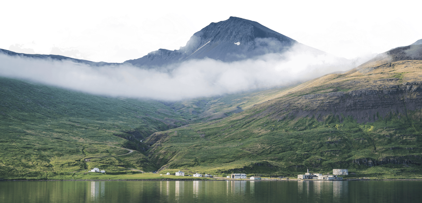
2. Hornstrandir Nature Reserve
Duration: The duration is completely up to you, which areas you choose to visit and how long you intend to stay
Activity Level Scale: Easy to Moderate (2-3/5)
Experience: Some experience is helpful a GPS is highly recommended because of connectivity issues. Little experience is needed with a guide
Path Conditions: Excellent and well marked
Water Supply: Better to fill up a water bottle in the morning
Challenges: The area is very remote so cell service can be brittle

When people start planning their trip around Iceland the Ring Road is often the route they decide to go with. It has everything from glaciers to black sand beaches to hot springs and waterfalls. However, the Ring Road skips out on one very important part of Iceland. The oldest part of Iceland, the steepest and the most remote. It skips out on the Westfjords, sometimes nicknamed the ‘Best Fjords’ and for a valid reason. This place offers vistas as you thought only existed in dreams, charming towns and villages like the olden days and locals with more flare and friendlier personalities than you could ask for.
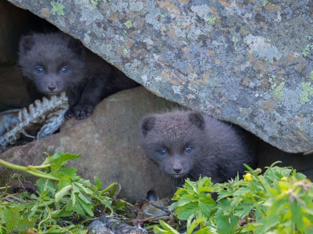
Hornstrandir is the northernmost part of the Westfjords, an Arctic Fox nature reserve and a paradise for all nature lovers. There you will find excellent hiking opportunities all around, beautiful and unique flora and naturally filled hot pool to bathe in.

Hornstrandir are visited on our all-inclusive, Ring Road PLUS the Westfjords trip Majestic Fjords which is the perfect tour for anyone looking to do a little hiking in Hornstrandir.
1. Laugavegur Trail ‘One of the Top Trails in the World’
Duration: 4-6 days
Activity Level Scale: Moderate Plus (3,5/5)
Experience: Without a guide you will need to have experience with a compass/GPS. With a guide less experience is needed
Path Conditions: Quite good but can be snow heavy early on in the season
Water Supply: Fill your water bottle up in the morning but there are streams along the way to refill
Challenges: Elevation gain and quick changes in weather
Good to know: The 6-day version of the Laugavegur trail also includes the Fimmvorduhals trek, perfecting the hiking experience in southern Iceland!

Chosen by the National Geography as one of the top 20 best hiking trails in Iceland the Laugavegur trek is one you must do! It starts in Landmannalaugar, the highlands geothermal paradise and takes you across astoundingly different terrain and landscape, in between glaciers, past volcanoes and into vast areas of untouched nature.
There are mountain huts along the way perfectly places for the trip to take four days. Meaning about 8-10 hours of hiking each day. If you were ever looking for a chance to reconnect with yourself or perhaps our darling Mother Nature The Laugavegur trail is simply perfect for you!

There is just something about trekking across the wilderness on a remote island in the middle of the Atlantic ocean. The freedom and the awe-inspiring views give you a filling.

Make sure to pack wading shoes, sunscreen, sunglasses, and extra batteries. You will not want to miss out on capturing these moments on film!
Having a hard time just choosing one hike to do in Iceland?
We have several options for those who want to try more than one of these amazing hikes. There are the Scenic Trails of Iceland meant for travelers at any fitness level. It is ideal for anyone who wants to experience the trueness of Iceland’s natural grounds. And then there is the Across the Wilderness- Iceland‘s interior mysteries and more for those who are looking to try out more than one and challenge themselves a bit in the meantime.
Rules for Hiking in Iceland:
- Tell someone where you are going and about what time you will be back.
- Check in once having arrived safely!
- Make sure to check the weather forecast daily, multiple times a day even.
- Get the Safe Travel App. It links you with all the help you will need if anything goes wrong.
- Research and prepare. Iceland is not like any other country and the terrain is different. Make sure to know what you are getting yourself into and pack accordingly.
- Newer travel without a GPS.